I actually hiked Gothics a few weeks ago, the day after I did Algonquin, Iroquois, and Wright. I finally have a little time to write up the trip report! I met my same friend from the previous day at the Ausable Club, but I was a little ahead of schedule, so I stopped on the side of Rt. 73 to take a picture of Roaring Brook Falls.
 Roaring Brook Falls from Rt 73
Starting around 7:30, we decided to take the more scenic East River Trail instead of walking The Road the whole length, it added a little time to our day, but we were greeted by a doe and her fawn, a treat that we would have missed on the boring Lake Road and then we encountered a mallard with its babies. Lake Road runs between the Ausable Club and the Lower Ausable Lake, a length of about 4 miles. Years ago hikers could hitch a ride on the bus that runs back and forth for a small fee, but hiker legend says that one day a hiker refused to give up a bus seat to a club member and we were forever banned from riding the bus. Some argue that the hike doesn't count towards your 46 if you ride the bus anyway. Bus rides are for sissies, whats an extra 8 miles anyway!
 Fawn hiding behind the tree

 Family of ducks
At the dam on the Lower Ausable Lake we picked up the Gothics via Pyramid trail. Although there was a chance of thunderstorms looming over us, the sky was clear for the most part. The trail leading up to Pyramid starts off pretty mild from the bridge, but eventually gets pretty steep. As we came up to the summit of Pyramid, we were encountered one of the most awesome views in the High Peaks, a view that could arguably be better than the one from Gothics. Pyramid Peak is taller than some of the 46 High Peaks in the Adirondacks, but it is not a true high peak because it is actually a subsidiary to Gothics. As you emerge from the forest onto the the summit, it seams as though you could reach out and touch the huge slides on Gothics. We fought not to get blown off the summit by the strong winds before ducking back into the woods into the col between Pyramid and Gothics.
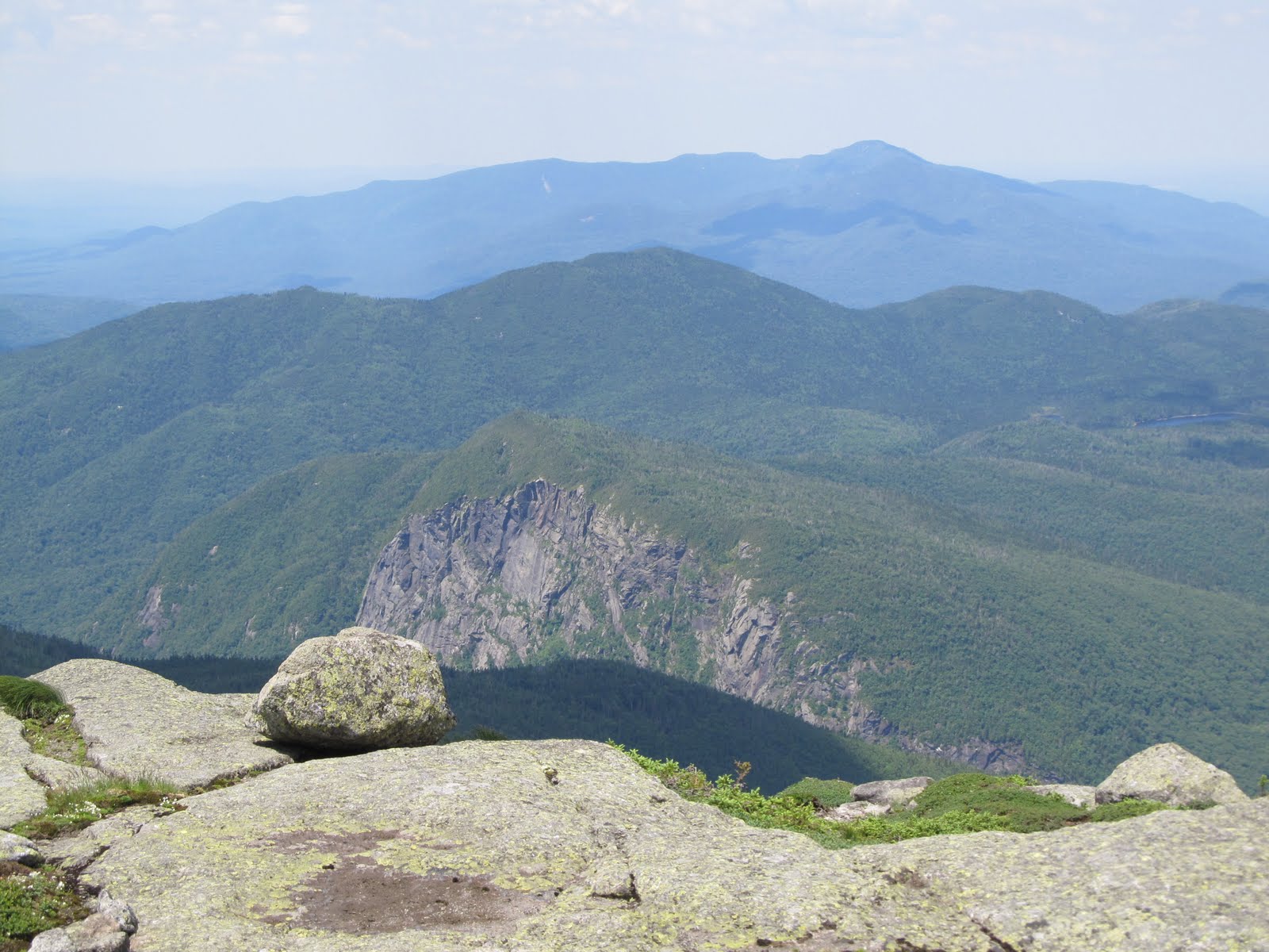
 On Pyramid Peak, Basin behind Gothics on the right, Marcy in the back
Near the summit of Gothics we stopped to eat and we figured out for the most part what we were looking at. The wind was pretty intense making walking difficult. There were great views of Marcy, Algonquin and Iroquois. We walked over to the true summit for more pictures and then went down for our descent on the Beaver Meadow Falls trail. We snacked some more under a large rock, and by that point the two of us knew pretty much everything that there was to know about each other - you do talk about a lot of random things in the woods! The sky was still clear at Beaver Meadow Falls, which was frozen last time I was there. I had taken the Beaver Meadow Falls trail up in the winter with intentions of doing Gothics and Armstrong, but the trail was in bad shape so we ended up going only to Armstrong and down over Upper Wolf Jaw instead. The same trail in two different seasons - but what a difference!
 View from Gothics

 Where Gothics and Armstrong meet at Beaver Meadow Falls Trail
 Beaver Meadow Falls
We were only at the falls for about 5 minutes, and in that time the wind changed and the sky had turned from blue to a very dark gray. We were drenched before we could even get our rain coats out. Thankful to be off the summit, we splashed through the Beaver Meadow Falls trail all the way to the Lake Road hooting like little kids. Where the trail meets the road, we saw a small family of hikers huddled under a rain poncho. Like a gift from Heaven, a bus pulled up right in front of them and opened the door. They quickly boarded the bus, and then slowly turned around and exited - members only!
The rain let up a little about a mile down Lake Road. We saw a couple more deer on the way out, they didn't seem to mind our presence, they looked at us a little sideways and carried on their way. We got to the gate around 4:30, not a bad day at all!
 Roaring Brook Falls from Rt 73
 Fawn hiding behind the tree
 Family of ducks
At the dam on the Lower Ausable Lake we picked up the Gothics via Pyramid trail. Although there was a chance of thunderstorms looming over us, the sky was clear for the most part. The trail leading up to Pyramid starts off pretty mild from the bridge, but eventually gets pretty steep. As we came up to the summit of Pyramid, we were encountered one of the most awesome views in the High Peaks, a view that could arguably be better than the one from Gothics. Pyramid Peak is taller than some of the 46 High Peaks in the Adirondacks, but it is not a true high peak because it is actually a subsidiary to Gothics. As you emerge from the forest onto the the summit, it seams as though you could reach out and touch the huge slides on Gothics. We fought not to get blown off the summit by the strong winds before ducking back into the woods into the col between Pyramid and Gothics.
 On Pyramid Peak, Basin behind Gothics on the right, Marcy in the back
Near the summit of Gothics we stopped to eat and we figured out for the most part what we were looking at. The wind was pretty intense making walking difficult. There were great views of Marcy, Algonquin and Iroquois. We walked over to the true summit for more pictures and then went down for our descent on the Beaver Meadow Falls trail. We snacked some more under a large rock, and by that point the two of us knew pretty much everything that there was to know about each other - you do talk about a lot of random things in the woods! The sky was still clear at Beaver Meadow Falls, which was frozen last time I was there. I had taken the Beaver Meadow Falls trail up in the winter with intentions of doing Gothics and Armstrong, but the trail was in bad shape so we ended up going only to Armstrong and down over Upper Wolf Jaw instead. The same trail in two different seasons - but what a difference!
 View from Gothics
 Where Gothics and Armstrong meet at Beaver Meadow Falls Trail
 Beaver Meadow Falls
We were only at the falls for about 5 minutes, and in that time the wind changed and the sky had turned from blue to a very dark gray. We were drenched before we could even get our rain coats out. Thankful to be off the summit, we splashed through the Beaver Meadow Falls trail all the way to the Lake Road hooting like little kids. Where the trail meets the road, we saw a small family of hikers huddled under a rain poncho. Like a gift from Heaven, a bus pulled up right in front of them and opened the door. They quickly boarded the bus, and then slowly turned around and exited - members only!
The rain let up a little about a mile down Lake Road. We saw a couple more deer on the way out, they didn't seem to mind our presence, they looked at us a little sideways and carried on their way. We got to the gate around 4:30, not a bad day at all!
All my pictures can be found here.