Sunday, January 8, 2012

Seymour

Hiking Mt. Seymour was a much needed hike in a high stress time of my life. We had sold our house and bought our house in the beginning of the month, moving in right after closing. Only a couple weeks had gone by, and we were involved in several home improvement projects. My mom's surgery was over and she was recovering well. While there were many things I should have been doing, there was nothing I wanted to do more than climb another peak.


Seymour is an unmarked peak, which is why I wanted to go with a group. The pace was fast, and with the wet weather we were facing, I was glad that we didn't sit still for too long. The morning began as an overcast and quickly turned to drizzle, at sometimes full rain. The trail was muddy, and the wet leaves were slippery at times.

We separated, unknowingly for a while, we didn't realize until we heard their voices in the distance. We yelled back and forth trying to come together again. At one point the rain turned to snow, and it was still rain over the other group. Our separate herd paths finally joined together and kept close until the summit.


At the summit there was less than an inch of snow on the ground, and there was some snow frozen on the trees, a preview for the season to come. Just passed the suit was an outlook, though no views through the clouds. We stopped for lunch, and a few of us headed down ahead. I was getting cold, my gloves had soaked through, and my feet had gotten wet. I stopped at the Ward Brook lean to to soak up some of the water in my boots and to put some dry socks on. I had to break out a pair of hot hands too. That's the tough part about hiking in the fall, the temperatures are low enough to make you cold, but warm enough to rain.


All photos can be seen here.

Thursday, December 29, 2011

Mt. Marshall

Yes, I'm still alive - just busy, and neglectful of trip reports. Life has finally started to settle down to normal, and I'm playing catch-up before my winter hiking begins! I hiked Mt. Marshall way back in July so it's about time I do my trip report! Unfortunately, my body was in the High Peaks and my mind was at home where I left my husband to stay with my mom just a day after she was released from the hospital with heart trouble. Sitting down several months later, I don't recall much about that trip other than wanting to hurry up and back down to an area of cell phone reception.


There was such a big turnout for the hike that we were required to break into a faster group and a slower group and maintain a miles distance between us. It was a beautiful day and the weather was perfect. I was in the first group and we started about fifteen minutes ahead of the second group, maintaining spotty contact with radios. We had a fun, chatty group and a quick pace.


I love this picture of Colden from the Flowed Lands. I hear now that there was a lot of blow-down and erosion in this area since Irene. We stopped a few times to pull out the map and some guides once we turned off the marked trail on to the unmarked portion of the hike.


There were views near the summit, where we enjoyed lunch and cookies. I regrettably was "that girl" pulling out her cell phone to use the one bar of reception to call home to check on Mom, who was doing well. I felt better knowing that she was okay, but still wanted to rush back down to the car. I think we made it to the car around 5pm. This would be the last of my hiking for a while, within a couple weeks my mom had heart surgery, we got an offer on our house, we sold the house, bought a new one, and moved! It really was a great hike, I wish I remembered and appreciated it more. Maybe I'll just have to do it again in the winter!


All my pictures from this trip can be found here.

Monday, July 25, 2011

Gothics via Pyramid

I actually hiked Gothics a few weeks ago, the day after I did Algonquin, Iroquois, and Wright. I finally have a little time to write up the trip report! I met my same friend from the previous day at the Ausable Club, but I was a little ahead of schedule, so I stopped on the side of Rt. 73 to take a picture of Roaring Brook Falls.


Roaring Brook Falls from Rt 73

Starting around 7:30, we decided to take the more scenic East River Trail instead of walking The Road the whole length, it added a little time to our day, but we were greeted by a doe and her fawn, a treat that we would have missed on the boring Lake Road and then we encountered a mallard with its babies. Lake Road runs between the Ausable Club and the Lower Ausable Lake, a length of about 4 miles. Years ago hikers could hitch a ride on the bus that runs back and forth for a small fee, but hiker legend says that one day a hiker refused to give up a bus seat to a club member and we were forever banned from riding the bus. Some argue that the hike doesn't count towards your 46 if you ride the bus anyway. Bus rides are for sissies, whats an extra 8 miles anyway!

Fawn hiding behind the tree


Family of ducks

At the dam on the Lower Ausable Lake we picked up the Gothics via Pyramid trail. Although there was a chance of thunderstorms looming over us, the sky was clear for the most part. The trail leading up to Pyramid starts off pretty mild from the bridge, but eventually gets pretty steep. As we came up to the summit of Pyramid, we were encountered one of the most awesome views in the High Peaks, a view that could arguably be better than the one from Gothics. Pyramid Peak is taller than some of the 46 High Peaks in the Adirondacks, but it is not a true high peak because it is actually a subsidiary to Gothics. As you emerge from the forest onto the the summit, it seams as though you could reach out and touch the huge slides on Gothics. We fought not to get blown off the summit by the strong winds before ducking back into the woods into the col between Pyramid and Gothics.


On Pyramid Peak, Basin behind Gothics on the right, Marcy in the back

Near the summit of Gothics we stopped to eat and we figured out for the most part what we were looking at. The wind was pretty intense making walking difficult. There were great views of Marcy, Algonquin and Iroquois. We walked over to the true summit for more pictures and then went down for our descent on the Beaver Meadow Falls trail. We snacked some more under a large rock, and by that point the two of us knew pretty much everything that there was to know about each other - you do talk about a lot of random things in the woods! The sky was still clear at Beaver Meadow Falls, which was frozen last time I was there. I had taken the Beaver Meadow Falls trail up in the winter with intentions of doing Gothics and Armstrong, but the trail was in bad shape so we ended up going only to Armstrong and down over Upper Wolf Jaw instead. The same trail in two different seasons - but what a difference!


View from Gothics


Where Gothics and Armstrong meet at Beaver Meadow Falls Trail


Beaver Meadow Falls

We were only at the falls for about 5 minutes, and in that time the wind changed and the sky had turned from blue to a very dark gray. We were drenched before we could even get our rain coats out. Thankful to be off the summit, we splashed through the Beaver Meadow Falls trail all the way to the Lake Road hooting like little kids. Where the trail meets the road, we saw a small family of hikers huddled under a rain poncho. Like a gift from Heaven, a bus pulled up right in front of them and opened the door. They quickly boarded the bus, and then slowly turned around and exited - members only!


The rain let up a little about a mile down Lake Road. We saw a couple more deer on the way out, they didn't seem to mind our presence, they looked at us a little sideways and carried on their way. We got to the gate around 4:30, not a bad day at all!

All my pictures can be found here.

Friday, July 8, 2011

Algonquin, Iroquois, and Wright from the ADK Loj

Three high peaks in a day sounds like a tough hike, but the Algonquin, Iroquois and Wright trek is really a decent hike, taking less time than some of the single peaks that I've done in a day. I went with a woman that I met through the ADK - we had hiked several hikes with the ADK before and had decided that we would venture out on our own this time.

We met at the Loj at 8am... the sky was blue, the temperature was mild and on the rise, and the bugs had finally started to calm down. We decided to go up Algonquin and Iroquois first, and hit Wright on the way back. The warm up mile down the Van Hoevenberg Trail was quick, we spent it chatting and catching up - we hadn't seen each other since Big Slide this winter! The trail turns to the left to go to Marcy Dam, but we stayed straight to go on to the MacIntyre Range. The trail was a steady incline from there to the summit, a total of 4.3 miles. The two waterfalls that we passed on the way were little trickles, my friend said they were so much busier just a week ago!


Near the summit of Algonquin we caught up with three women, all originally from Keene Valley and back in town for a brief visit. We chatted with them all the way up to the summit where we were greeted by the summit steward and the largest fly I've ever seen. The summit steward, who climbs this mountain or a few of the other popular peaks several times a week in the summer, educates climbers on the importance preserving the vegetation on the summit. He showed us pictures of Algonquin and Marcy from years ago before the program started, and a more recent picture. Comparing the pictures side by side, it's amazing how well the steward program has worked. There are tiny little wild flowers and other vegetation now, however, years ago the rocks were completely bare.

The view from Algonquin was amazing with 365 degrees of beauty. Whiteface, Mt. Jo, Heart Lake, Iroquois, The Santanonis, Giant, Marcy, Skylight, Gray, Colden, and so many more landmarks were visible.


My hiking buddy led the five of us to the unmarked herd path to Iroquois. The trail was narrow and muddy, and at times the branches would latch on to my hair, pack, or pants snagging me back. The path heads over Boundary, a bump between Algonquin and Iroquois, that doesn't count as a high peak due to its proximity to the other two mountains. There's one tricky spot just before the summit of Iroquois, a tall rock with a small foothold but no branches or roots to grab onto to pull your self up. I gripped the rock with my fingers and pulled up on my knees only to slide down on all fours scraping up my elbow. This is where long legs would come in handy. I repeated the same maneuver a couple times before I was able to get one of my legs all the way up. We ate lunch on Iroquois and took pictures of Algonquin, Wallface, and the surrounding High Peaks Region. We had to go back over Algonquin again to head over to Wright.


You know you have hiked a lot when people start to recognize you in the wilderness! I ran into a fellow hiker that I hiked with in the Santanoni Range, and was recognized by someone who follows my trip reports.

The rocks seemed more slippery on Wright, good thing it wasn't raining! It was less than a half mile from where the trail breaks off to the summit, and we were still feeling great. Looking over at Algonquin, we could make out the trail that we had just come down. There was another steward on Wright, this was her summer job between college semesters.

Wright Peak is the site of a tragic Adirondack story. On January 16, 1962 a B-47 bomber was on a practice mission from Watertown to Plattsburgh Air Force Base when it lost radio signal and never arrived at Plattsburgh when it was supposed to. An extensive search began, and it was determined that the plane clipped Wright Peak just below the summit and its shattered pieces spread down the mountain and into the col between Algonquin and Wright, leaving no survivors. Most of the wreckage was under several feet of snow, up to twenty feet in some spots. Two of the men's remains were found about a week after the crash, the remains of a third man were found later. The remains of the fourth crew member were never found. At the site of the crash a few pieces of the plane remain, and a plaque honors the four men that lost their lives that tragic day.


We returned to our vehicles around 5pm, about a nine hour day including summit time.

All of my pictures can be found here.

Thursday, June 30, 2011

Mount Washington, New Hampshire

For the first several years of my life, my family would make at least a couple trips to Maine every year. In the fall we would celebrate Thanksgiving with family, in the summer we'd stay at the family camp until it tragically burned down in the late 80s. After the fire, our trips decreased in frequency, but I would go at least once a year, sometimes with just Nana. The drive was long, but scenic and beautiful. It would be broken up with stops at Queeche Gorge in Vermont, and a quick meal in St. Johnsbury. We would drive by Mt. Washington, though you could never see the top which was hidden in the clouds. I always wanted to climb it. An opportunity arose to go with four of the toughest women I know, and I couldn't turn it down.

Mount Washington is known for many things. It is the tallest mountain in the Northeastern United States. It boasts that it has the world's worst weather, if that is something to brag about. It had the world record for recorded wind speed - 231 MPH in April of 1934, a record that was broken by Australian Typhoon Olivia in April of 1996. The bragging rights on Mt. Washington remain, however, because this measurement was recorded by man. There is a scientific and meteorological explanation behind these strong winds, involving jet streams and currents and things I won't pretend to understand. It is these winds and the rapid changes in weather that can make the hike a dangerous one.

Backpacker Magazine lists the peak on its top 10 Most Dangerous Hikes in America and calls it the most dangerous small mountain in the world. What makes a 6288ft peak in the White Mountains so dangerous is the rapid changes in weather, strong wind gusts, and risk for hypothermia, not to mention the falling ice and hiker fall risks. That being said... it was a lovely day. However, I would never belittle the risks that you can encounter in the woods. Preparation and knowing when to turn around are key in any hiking situation.

Three of my fellow hikers arrived in Gorham several hours before my carpool, which gave them time to head to the Pinkham Notch Visitor's Center to discuss with the staff there what our best options were for trail conditions and weather. Our original plan was to attempt Tuckerman's Ravine Trail, but our research showed that part of it would be closed due to falling ice, crevices, and undermining. The Visitor's Center confirmed that it was closed and recommended the Lions Head Trail, as we had figured and planned for, round trip.

We left the Top Notch Inn at 6am and headed for the Pinkham Notch Visitors Center. We geared up and were on our way at 6:25. Our original plan was to leave at 7am, but the chance of afternoon thunderstorms persuaded us to an earlier start. The sky was overcast, but the trail was dry. We started on the Tuckerman's Ravine trail which we followed over two miles to the turn off to the Lions Head trail. We had only paused for rest a couple of times, taking some pictures along the way, but we were surprised to have made it to the turn off so quickly... Only two miles to the summit of Mt. Washington! While this was a shorter hike than the Adirondack High Peaks that we are used to, what made this different was the lack of a few warm up miles before the ascent. You start climbing right from the start with little reprieve.


The views along the Lions Head trail were amazing. The clouds broke up and blue sky was visible, with the sun peaking through at times. We were above the clouds, a view I had only seen before from an airplane. We could not see the ground, just the clouds, and the mountain tops above them. We took advantage of the weather and took many pictures along the way, who knew how long this would last! The trail was rugged and steep, the lack of soft ground was wearing on the knees.


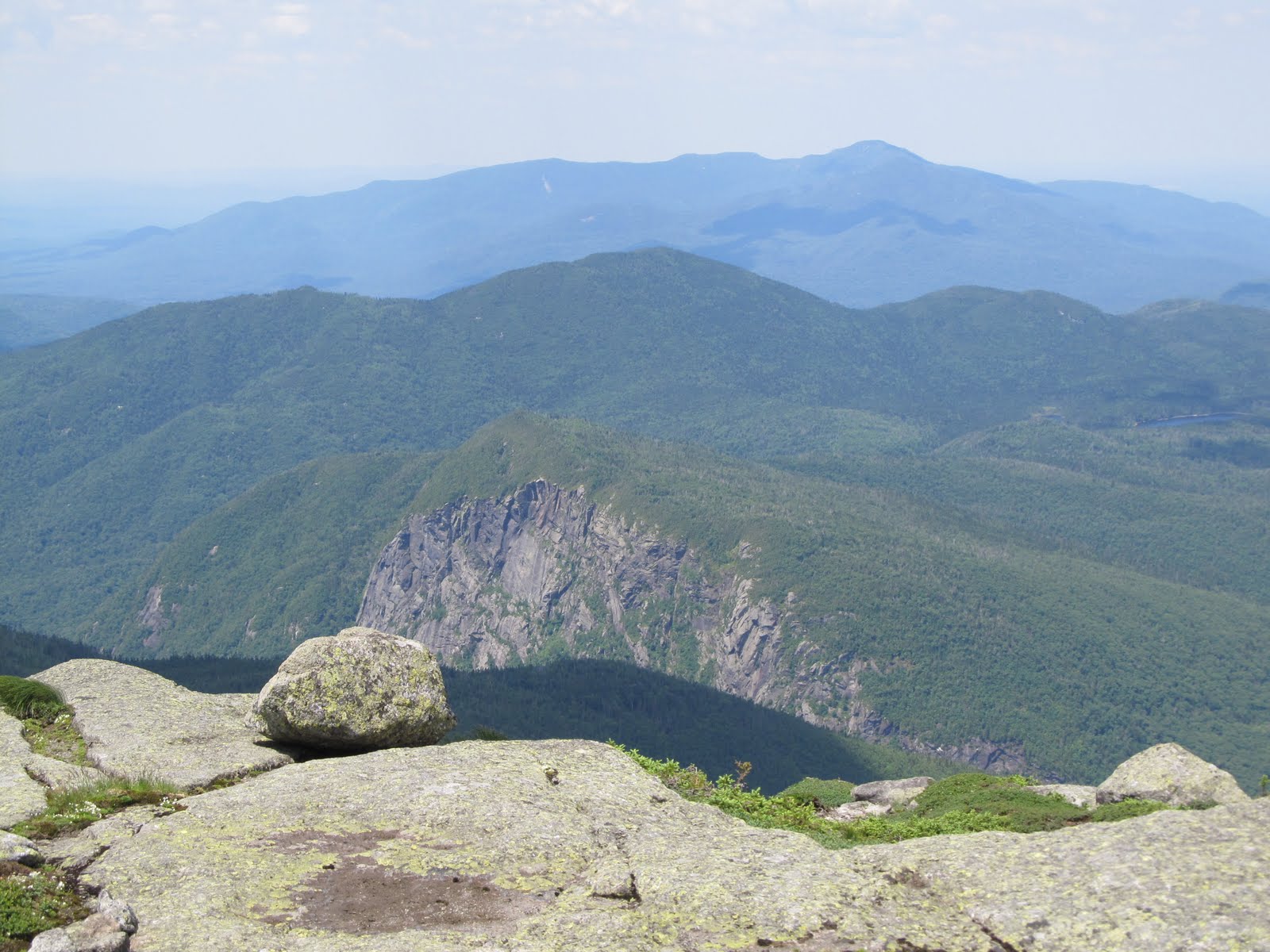
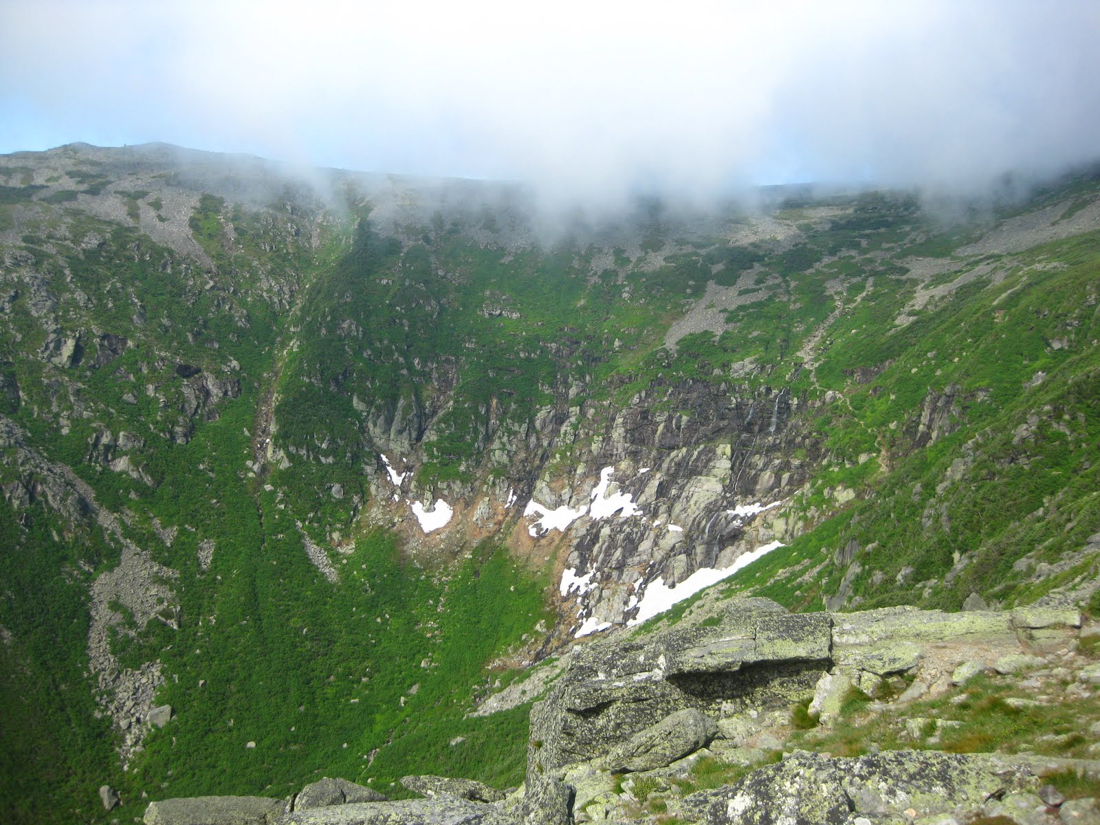
As we neared Lions Head, the summit of Mt. Washington was occasionally visible, but it would frequently tuck away behind a large cloud. The wind was picking up and the clouds were drifting by us rapidly. We stopped on Lions Head to put on our hats and long sleeves, it was windy but tolerable. Tuckerman's Ravine was to the left, Huntington's Ravine to the right. You could see the trail and the ice in Tuckerman's Ravine, and its huge headwall. Up ahead was the summit, only a mile away. I had seen this so many times before. A false summit or overlook with the true summit seemingly so far away, but it always arrives sooner than expected. Not this time, though. That was definitely the longest mile I have ever experienced. The final stretch was similar to the the loose rock on the Macomb slide, the exposure was like that on Haystack or Marcy.


A man was heading down from the summit and we stopped to chat. He said that he had taken the Tuckerman's Ravine trail up, and that he was going back down the same way. We thought it was closed! He said it was muddy and wet but doable, he recommended it. We'd talk to the rangers at the summit, and see what they think.

As we neared the summit, the clouds started moving in faster and darker. It would rain for sure. We could no longer see Tuckerman's Ravine, the mountains, or fellow hikers for that matter, but we were almost there. Taking our final steps, the sound of motorcycle engines signaled that we were almost there. From the top, you could barely make out the Tip Top House, weather station, and a train. The clouds passed again, and it was blue skies.


At the true summit we took pictures, and some automobile climbers took a group photo at the sign. We checked out the Tip Top house, and posed for pictures at the dining room table, pretending to have tea. This is the remaining part of the original structure, once a Pre-Civil War hotel.


We enjoyed a picnic lunch at the Summit Building which offers a snack bar, gift shops, exhibits, information center, running water bathrooms, and even a post office. The rangers at the information and registration desk said that Tuckerman's Ravine had re-opened that day, but suggested that we go back down Lions Head as the trail would be muddy and wet. We enjoyed our time at the summit, especially when we saw that the clouds had broken and there were amazing views. We took some more pictures before heading back down around noon.


The descent was steep, and we separated a little. While two members of the group stopped to take more pictures, the rest of us headed down, following the cairns. We came to one last cairn and no others were in sight. Perhaps they were visitor made cairns, leading in a wrong direction. We could see where we needed to go, but lost sight of the trail and our other two hikers. We were concerned, but not worried, as long as we could see Lions Head we were going to be OK. Turns out that we were both yelling to the others, but neither of us could hear the calls over the wind. We reunited before Lions Head and tried to figure out where we went wrong. Whatever happened, we all were on the same page, knowing that the others would surely stop at Lions Head to regroup!

I was grateful to have borrowed Sister's pole so that I'd have two. The steep descent on rocks and boulders was definitely eased by a second pole, as I usually hike with only one. Our spirits were so high on the way down. We could not get over the great luck we had in the land of the World's Worst Weather. We even speculated on a future trip - perhaps the Grand Canyon!

We took a short detour to check out another waterfall, and before we knew it we were back to Pinkham's Notch at 3pm. I weighed my pack, post hike - a whopping 20 pounds after I had drank a lot of my water, and eaten my lunch, adding only a T-shirt and patch saying "I Climbed Mt. Washington." No wonder I didn't blow off the summit!


The rest of my photos can be seen here.


Sunday, June 12, 2011

Dix Mt.

I finally finished the Dix Range yesterday, though the weather was not nearly as cooperative as it was during my first visit. This time I went with the ADK and we started from Rt. 73, near Keene, at the Round Pond trail head. There are two approaches, that I know of, to just hike Dix Mountain. The other approach would be coming from Elk Lake, like I had when I climbed Macomb, East Dix, South Dix, and Hough. We originally were going to head in from that direction, but a boyscout troop had contacted the leader hoping that our group would be willing to help carry in supplies to build a latrine, which was one boy's project for becoming an Eagle Scout.

We each took something to bring to the Boquet River lean-to where the the aspiring Eagle Scout was going to build the latrine. This was a long, wet four mile walk for the scouts. The precipitation varied from being a light drizzle to a steady rain. Fortunately we avoided the snowfall that was later reported by a friend across Rt. 73 on Giant! The trail immediately begins at an incline, though it does become more level at Round Pond. Round Pond looks like a quiet and peaceful body of water. There was some misty fog lingering above the water - it would have made for a nice photograph but my camera spent most of the time safely protected from the elements.


We took shelter in the lean-to while waiting for the scouts and their leaders to catch up. As we watched them line up their materials, we realized that we hadn't quite understood the design. The latrine was described as an outhouse without a roof, sacrificing protection from the elements for less odor and more light. Apparently you also sacrifice privacy, as the latrine was basically a free standing toilet bench - a box with a beautifully carved toilet seat shaped hole and a lid. Perhaps one day Luke Barclay will include the Adirondacks in another edition of A Loo with a View.

We left the troop with their supplies and continued on as a group of 9, all women except the poor leader. Though it was a Younger Members Group hike, the hike is open to anyone including the young at heart. There must be an honorable mention to the woman whom I was told is 76 years young, a veteran of the 46ers earning her badge in 1995. That is just so amazing! She came along because Dix holds a special place in her heart. It must for her to come back and do it in the rain!

We headed to the base of the large slide, which we had to climb up a little before following the trail around to the right. It was quite slippery with the rain and runoff, we were glad that there was a trail to skirt around the slide so that we didn't have to go up it. From here the trail began to get much steeper. We rested at the junction with Hunter's Pass and decided that some of us would go on ahead to the summit and continue on to Hough quickly and meet again at the same junction. I already had Hough but I would get chilled when standing still so I decided it would be best for me to keep on moving.

The on the summit we had a nice couple take our picture. There were no views due to the weather, but on a clear day you can see Giant, the Great Range and the other mountains in the Dix Range. We continued on to the end of the Beckhorn where we knew were were supposed to leave the marked trail and go towards the left for the herd path to Hough. Our leader had stayed back with those who did not want to climb Hough. We are pretty sure we found the spot where the trail heads down to the left, but with the fog being so thick, it was hard to tell if there was any solid ground on the other side of the brush. We followed the marked trail for a short distance, wondering if we hadn't reached the herd path yet, but we had no luck. We turned around, my poor friend who is so close to finishing will have to come back again.


We were hoping on the way down that the boy scouts were still at the lean-to and had possibly made a fire for us as a warming station, but no, they were long gone. We got back to the car around 7, making it a much longer than expected day. I was soaked, a little cold, and one peak closer to the goal.

The whole photoset can be seen here.

Sunday, June 5, 2011

Thoughts Along The Way

The other day I was asked, "My gosh, look at you, why do you do this to yourself!?"

This was a question that was asked of me by a friend who was looking at the collection of cuts, scrapes, and bruises that I had acquired after a weeks vacation that involved three trips to the high peaks and six more notches on my aspiring 46er belt.

A bruise on my left upper arm, on the bicep specifically, resembles a sucker punch. Actually, it kind of was a sucker punch, from the stump of a dead branch on a dead tree. The dead tree actually caught my fall and potential face plant going down Redfield, so I guess I can't be angry with it. This was rebruised a week later in the Santanonis by a very much alive branch that snapped back and whacked me. That was just one bruise, aside from the dozens bruises serving as temporary tattoos on what I call my "summer legs." I haven't gotten my bike out yet, but my summer legs tend to include hiking bruises, as well as bike chain grease that never seems to wash off completely. Other battle wounds include foot blisters and now two swollen Achilles, not to mention my body's struggle with dystonia.


My answer then was that I do it for the views, the goal, and the adventures along the way. Though up to that point of the spring season, I had hiked peaks without the best views, except Haystack, and views obstructed by thunder clouds. After having three more peaks to reflect on the question, I guess my response would be to answer the question with a question. It's not "Why do I do this to myself," but "Why don't you do this for yourself?" And maybe, "Because I can."

You always encounter adventures when hiking, whether they are wildflowers and wildlife, views, narrow herd paths, large cliffs to scale, or abusive trees. It is all one photographic, muddy, bug infested, and spiritual journey. You learn a lot about life, nature, and yourself along the way. You grow stronger, both physically and mentally. If you told me two years ago that I would be scaling cliffs, walking across rivers, rock climbing without the technical gear, sidestepping across an icy ledge with nothing to catch you accept a snow-covered void, and completing an entire range in a thunderstorm I might have decided to take up a different hobby, but I certainly wouldn't have believed you.


While hiking Gray, Skylight, and Marcy, I got in a discussion with a fellow hiker in the group about the journey of being a 46er. It starts off as just climbing a couple high peaks. Then you decide to go for all of them, but you'll take your time, you have your whole life ahead of you. Then it becomes an obsession, perhaps addiction. As you get closer to the end, you don't want to do anything else. You don't want to hike anywhere else. There are so many other mountains that you want to climb and enjoy, but you don't. You want to save your body and strength for finishing. What if you get hurt hiking somewhere else and can't finish because of it? What if you take your time and something tragic happens when you are so close? We agreed that we all told ourselves that we'd take our time, finish when we finish. Perhaps we all started off that way. But something strange happens to many people when they have more high peaks completed than they have left. They develop goal date, season, or age, as well as a goal finishing mountain. And it's not a long term goal. Many of the people that I have hiked with that still have about 10 left want to finish by a certain point this summer, for various reasons. So they can have said they did them before the age 50, or because they started in a certain month and want to finish in that month. So someone special to them can be at the top. I still have 15 left, including the dreaded Sewards and Allen, all of which are difficult and tailless, and I need someone more experienced to lead me in. Working weekends and having a wedding to participate in, I'm sure that I can't finish this summer. Look at me, I'm already worried about it and it isn't even summer yet!


My goal is to finish next summer, on Whiteface, so that my husband can drive my mom up. I'd like to make a weekend out of it, stay in Lake Placid, go to our favorite brew pub. Lake Placid is great in the summer, and the road up it isn't open year round. The thought of not being done until a year from now drives me nuts. I have 8 or 9 trips left assuming it takes two trips to complete the Sewards, and only 7 weekends that I can go between now and the end of September. Three of those trips I definitely need to be led in with someone experience. We talked about how silly it is to be stressed out by this, but many of us seem to have this in common! At what point does it change from being a fun passion to being a stressful chore? I guess I need to keep telling myself to step back and enjoy the journey, the high peaks will still be there next year...


Gray, Skylight, and Marcy


It seems like a lot to hike three high peaks in one day, but if you are going for all 46 of them, it is definitely the way to go. I had already hiked Mt. Marcy nearly two years ago, but that is one I'd always be willing to do again, at least in good weather. In this case, it was actually shorter distance to climb one more mountain than to go around!

This trip was an ADK outing. Some of us met around 4:30 am, or earlier, the rest of the group met at the trail head around 6:10am at the Adirondack Loj. A slight chance of rain or thunderstorms was in the forecast for the late afternoon, but otherwise mostly sunny and cool. Perfect hiking weather! We were geared up and ready, starting about 6:30am.


From the Loj we took the Van Hoevenberg trail 2.3 miles to Marcy Dam. From Marcy Dam, we followed the Avalanche Pass trail for about 1.1 miles to the Lake Arnold trail, which is where some climbing started. We followed the trail beyond Lake Arnold and crossed the Opalescent River and continued to where Feldspar Brook meets the Opalescent River for a total of 3.5 miles. We picked up the Lake Tear of the Clouds Trail and followed this section of the trail for maybe 1.1 miles to Lake Tear of the Clouds.

Lake Tear of the Clouds is the highest pond source to the Hudson River, at 4346 ft. From Lake Tear of the Clouds, you can see the top of Mt. Marcy, also known as the Cloud Splitter. Cloud Splitter is the English translation of Tahaus, the Native American name given to Mt. Marcy.

"But how wild and desolate this spot!...First seen as we then saw it, dark and dripping with the moisture of the heavens, it seemed, on its minuteness and its prettiness, a veritable Tear-of-the-Clouds, the summit water as I named it."
- Verplank Colvin, 1872


This was a nice place to stop and rest to take pictures. Such a peaceful little pond full of rich history. It is said that the then Vice President Theodore Roosevelt, while vacationing in the MacNaughton Cottage in the Upper Works, had just finished climbing Mt. Marcy and was in this very spot when he was notified that President McKinley had been shot.

"...way up among the Adirondack peaks is a little pool asleep. Through the long winter it lies-a solid crystal almost-under the accumulating weight of many snows, barren of all life save that which, like itself, waits for the summer's sun to warm it into tardy being and bring with the rank green fringe its swarms of batrachian young."
-Seneca Ray Stoddard, 1885


While state surveyor Verplank Colvin, and his guide, William Nye, were the first white men to find the pond, it was likely to be found, used, and appreciated by the Algonquins, Mohawks, and other Native Americans long before.

The herd path up Gray Peak, the tallest unmarked high peak in the Adirondacks, is marked by a cairn as you reach Lake Tear of the Clouds. It wasn't too difficult to climb, and looking behind on the way up you can catch glimpses of Skylight Mt. It is a herd path, however, so it was a narrow route, so I was frequently getting scratches and slaps from branches on both sides, but that's all part of the adventure.

Just before the summit, to the right, you can see Skylight clearly. A very short distance ahead is another lookout towards Colden and the McIntyre range to the Northwest and Whiteface to the North. From the summit marker sign you can see the top of Marcy. We rested here for about 20 minutes, ate some lunch thinking that the summit of Skylight might be too windy.


We headed back down to Lake Tear of the Clouds and around the right hand side of it, stopping to look at Marcy and the target lichen on the side of a boulder.


We continued toward the Four Corners, a distance of about 0.3 miles. From here you can go up to Skylight, Marcy, or Panther Gorge. We followed the trail to Skylight for about 0.5 miles to the summit, each picking up a rock to place on the summit on the way. These rocks are used to protect the small amount of vegetation on the summit, and according to legend, it will rain if you do not carry up a rock to throw in the pile!


Description of the purpose of the rocks at the Four Corners


The summit of Skylight was amazing, perhaps offering the best view in the High Peaks region. Yes, Marcy provides the highest view, but when you are on Mt. Marcy, you can't see how beautiful it is! We lucked out with the weather - no sign of rain, and the wind was a gentle, welcomed breeze. We lingered for a while on the summit looking at the views and the wildflowers. We were informed by a fellow hiker that the Alpine Azalea (thanks Sister for helping me remember the name) were in bloom. They are an endangered flower and if I remember what the hiker said correctly, Skylight might be the only place in the Adirondacks where they bloom?


We waved over to the McIntyre range where another ADK group was, conquering the entire range in a day - what an admirable feat! We looked up at Mt. Marcy with awe, but also with a groan. We could go around Marcy, but it is actually easier and more direct to head back to the car by climbing up and over Marcy's summit. Besides, two people in the group needed to climb Marcy still for their 46. We left Skylight and headed down to the Four Corners.


From the Four Corners, it was only 0.8 miles to the summit of Marcy. This is according to the ADK High Peaks Region book. Someone had ripped the millage off the trail sign as though to say, "Don't worry about it." The summit of Marcy was just as beautiful as it was the first time I had gone, though still a crowded, popular summit. After hanging out there for a while, remarking on the impressive time we had made so far, we headed out determined to get to the car before 6:30, making it an under 12 hour day. We took the Van Hoevenberg trail route back to the Loj, the most popular trail from Heart Lake to Mt. Marcy, probably because it is only 7.4 miles. We got to the car at 6:20pm or so - a total of about 18.5 miles in just under 12 hours! Not to mention the 90 minutes in summit/rest time we had!


All my pictures can be found here.