Showing posts with label Catskills. Show all posts

Tuesday, October 13, 2009

Hunter Mountain: Completion of the Fire Tower Challenge!

Columbus Day, 2009

Our final fire tower for the badge, but certainly not our last fire tower!

It was a last minute decision to go up the Spruceton trail on Hunter Mountain instead of the more difficult Becker Hollow Trail. The Becker Hollow trail was less hiking millage, though more steep, and it would have saved us about 45 minutes in driving time which is why it was our first choice. No longer bound to the clock, and Sister plagued with a head cold, we decided to make the drive to the more southern, and less steep, Spruceton trail. It follows an old jeep road and horse path to the summit. The foliage along the trail seemed slightly past peak, but colorful leaves sprinkled on the ground allowing for some really pretty pictures and memories.


The trial follows Hunter Brook for a while, and crosses the brook on a wooden bridge. With switchbacks along the way we passed the old site, which we didn't notice, of a lean-to that burned down a few years ago. We came to the junction of the Colonel's Chair path where one can take the gondolas.


A spring is located on the right of the trail, but don't drink the water! A sign at the trail head warns of parasitic contamination, I'd say most likely from the horses that make the trip to the top.


Just passed the one mile to go mark, Sister's eye caught the tower in the far distance. Not the best picture opportunity as the bright sky consumed most of the tower. Sister's eagle eye also noticed a collection of needle ice in the moss on the edges of the trail. Needle ice is formed when the unfrozen ground water seeps up through capilary action and freezes as it hits the air at freezing temperature. It curls as it freezes making a design that resembles ribbon candy.


Fire tower in the distance

If you bring your horse, they do have landings to mount and dismount at the top and bottom of the trail.

The popular summit was crowded with other groups of hikers. We were disappointed that the cab was closed, but the view from the top landing was spectacular. Ski slopes were visible, and the surrrounding Catskill Mountains decorated with the remaining orange and red leaves. The observer's cabin stands at the summit, making a nice place to enjoy your lunch.


According to "Views from on High" by John P. Freeman, the first tower on Hunter was a wooden one standing 40 feet tall. It was the first of three built in the Catskills that year. In 1917 it was replaced by a steel tower, and was relocated from it's original position to the current one in 1953. It stands at 4040 feet elevation, giving it the honor of being on the highest point of all the fire towers in New York! It was abandoned as an active fire tower in 1990 and eventually condemned for public use. In October of 2000, the tower was reopened for public use with restored steps, landings, floor, roof, paint, and windows!


To see all the pictures from Hunter Mountain, check out my Flickr page.

Saturday, September 26, 2009

Mt. Tremper via Willow Trail

After three days of partying (an out of town rehearsal dinner and wedding, and a high school reunion) I was ready for a wholesome activity. Sister and I chose Mt. Tremper because it was the closest fire tower hike left to climb, and it was a shorter hike; no need to throw my I'm-getting-too-old-to-party-like-this-body into shock. So down to the Catskills we went. We chose the Willow Trail approach because our guide book said it would save 600 feet in elevation change but only add 0.2 miles round trip. Perfect hike for my condition!


The trail begins at the dead stop end of Jessup Rd. Our guide book says its 6.4 miles round trip. We were too busy talking about my eventful week and missed the turn sign through the meadow to the trail. We came to a gorgous building with solar panels and a field of wild turkeys. The road turned around and we encountered some loggers who informed us that we did miss a turn a while back. That excursion probably added only a half mile onto our hike.


When we got back on track we climbed a little and walked along the ridge where we could hear the helpful loggers down below and a snake (not a rattlesnake) sailed over the toe of my boot. We saw Doll's Eyes in person for the first time ever! We moved forward for quite some time before getting to a junction where a sign said that there was over two miles to the summit. That, according to our calculations based on the guidebook, would mean that we had only walked about a mile from the trail head?! We took ino consideration our missed turn in Albuquerque, but it still didn't seem to check out. We hiked all the way to the summit, and towards the end of the trail we were both amazed at how it seemed like the longest 3.2 miles of our lives. I blamed it on my exhaustion and the wine from the night before.

Doll's Eyes

At the summit, much to our dissapointment, the fire tower appeared to be closed and a little unsafe to climb. Several beams were on the ground, and we speculated as to whether it was under repair and reconstruction or if the tower was going to be taken down. The pulleys and large C-clamps made us think that a restoration was in store, but the spokesperson for the family at the summit insisted it was being taken down.


No views are available from the bottom of the tower, but a large rock provided a nice sitting spot for lunch. After lunch and picture takin we continued a little down the Phoenicia trail to check out the lean-to.

Even the way down seemed equally long. I was starting to feel ashamed - we have conquored several mountains more difficult that this trail, what was my problem?! This was a fairly easy trail! We had estimated that the 6.4 mile hike would take us 3.5 hours at most, but it took us five hours including summit, picture taking, the little accidental excursion and the walk to the lean-to. How shameful! What a pleasant surprise it was when Sister found out that the Willow Trail of Mt. Tremper, according to the Catskill Center website, is actually 4.2 miles to the summit, making it about two miles longer round trip that we had thought!


An email to a Catskill Fire Tower Volunteer clarified the fire tower situation. No worries, it is under repair and it isn't going anywhere! We should have known that they wouldn't let it come down!

Tuesday, September 1, 2009

Overlook Mountain and Unexpected Mountain House Remains

On the rainy Saturday morning, Sister and I made our way down the the Catskills to climb Overlook Mountain. It was our fire tower of choice, as it was the shortest distance to cover of the three Catskill fire towers that we have yet to climb, and it was raining.

We started up the wide old carriage road, discouraged that it was not a trail under tree cover. The sky was open and raining down onto us; the rain was not heavy, but it was constant.

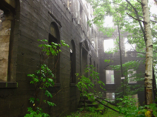
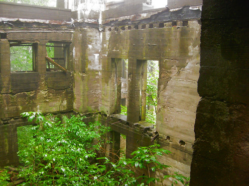
We were expecting to run into an old mountain house remains, perhaps a small foundation and a chimney. What we weren't expecting was the dilapidated monstrosity that we found. This was no observer's cabin!


According to my Views from on High book by John P. Freeman, this was a the remains of a hotel. This hotel was originally a temporary one, built by James Booth in 1833. It was given permanent status in 1871, but burned to the ground in 1874 on April Fool's Day when staff ignored a child who was trying to convince them that the smoke was darker than usual. It was rebuilt in 1878, only to burn down again in 1924. Efforts to reopen were abandoned in 1939, while in the midst of rebuilding it again.


According to the Castkill Center, the Overlook Mountain Hotel, in its prime, had the distinction of being the highest in the Catskills, at 2920 feet, and housed over 300 guests.


Rob Yasinsac provides a lot of information on the Overlook Mountain house. In his post he states that the first construction of the hotel in 1871 was done by Lewis B. Wagonen, a designer and builder from Kingston, NY. After burning down, the reconstruction of 1878 was done by the Kiersted Brothers of Saugerties. The work on the final structure was begun by Frank P. Amato. The concrete frame was quickly rebuilt, along with a chapel, underground water and ice facility, stables, and a power station, but the construction was never finished. The hotel was boarded up in 1940 and damaged by fire in 1941. A final blaze in 1961 took down much of the architecture and the roof-top tower.


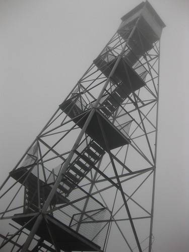
The tower at the summit is restored and climbable. There are nice profile maps for the surrounding mountains along the sides of the roof of the cab, providing the climber with a guided tour of the visible area. Unfortunately, the clouds were so thick we couldn't see out the windows!


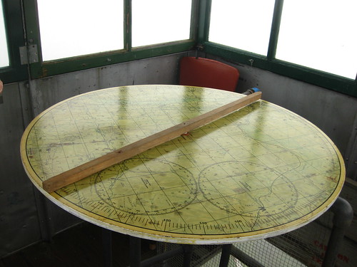
The tower is the newest of the remaining towers, built in 1927. It originally stood on Gallis Hill until it was moved to Overlook Mountain in 1950. It was eventually abandoned in 1989 and closed. Ten years later the tower was restored and opened again for climbing. In the cab a range finder and alidade are displayed.


Click here to see all my pictures on Flickr.

Tuesday, August 26, 2008

Red Hill

The second Catskills fire tower hike (the overall ninth fire tower mountain,) as well as the main reason that we dragged the husbands down to the Catskills for camping was Red Hill. At only 890 feet in elevation change and a round trip walk of 2.8 miles, it hardly seemed worth driving 3 hours to just do this mountain so we made a weekend out of it, camping at Mongaup Campground and hiking up Balsam Lake Mountain the day before.


We were accompanied on this hike by our loving, willing, but less than enthusiastic husbands, who came because it meant a lot to us. Once again, it was a small miracle that we found the trailhead., validating my claim to my husband, that no, there are not huge signs directing you to mountain trails.

We drove over back roads and perhaps even a mountain to get to the trail head in Denning, a town in southern Ulster County. My brother-in-law had more faith in his car than I had in my Corolla to get us down the bumpy dirt road to the parking lot closest to the trailhead. We found some self guided tour pamphlets, like the ones at Mt. Goodnow and Blue Mountain which provided a little lesson in nature along the way. It described Along the way we saw Lycopodium, Nectria, Mountain Wood Fern (the fern that florists use in arrangements,) Yellow Birch, Hemlock, White Pine, Moss, pudden stone, bluestone slabs which were dropped at its location by a glacier, and of course the fire tower and cabin.

"Pudden Stone" stones inside rocks

Bluestone, left by the glaciers

Sister and I were excited to find yet another Catskills interpreter at the summit - an opportunity that is not as frequently provided in the Adirondacks. He was actually the one that made some hand mountain profile labeling maps inside the tower, so you could see based on the outline of each mountain which peaks you were looking at.


Me and Red in front of the Red Hill fire tower

From the top you can see 98 peaks and over 3000 acres of land. The land was only occasionally frequented by Native Americans, and later settled by Dutch, English, Irish, and Germans. Some of this history of the region includes logging, bluestone quarrying, leather tanning, winter green and blueberry harvesting, trapping, fishing, mountain house tourism, railroads, and World War II pilot training.


The cabin

Red Hill was selected to be a steel fire tower site in 1920, and was the last staffed tower in the Catskill Forest Preserve, which was last staffed in 1990.


Pictures inside the cabin

For all the pictures from this hike, see my Flickr set.

According to "Views from on High" by John Freeman, the summit Elevation is 2990 ft, with an elevation change of 890 feet. The difficulty is described as being a short hike, never very steep, though my husband begs to differ.

Thanks to the Red Hill Fire Tower Committee for providing a paper trail guide along the hike, from which this information was obtained!

For a list of those who served the Red Hill Fire Tower, visit:
www.denning.us/redhill/firetower/cat03.html

Wednesday, August 20, 2008

Tour of Balsam Lake Mountain

My favorite fire towers are always the ones that are not only climbable, but with access to the cab as well. My first Catskill fire tower hike was an amazing experience - not only was it staffed with interpreters,but one of the interpreters had a special connection to the mountain.

Our hike started off on the Dry Brook Ridge Trail beginning at the southern approach to Balsam Lake Mountain in Beaverkill, NY. The sign to the "fire tower" almost got lost in the glare of the sun, but fortunately Sister's eyes are better than mine, as I would have led us down the path marked "trail," go figure. I'm not sure where that would have brought us to, but I think it may be part of the southern "loop."

Almost overlooked the sign to the tower

From the Dry Brook Ridge Trail, we met the Balsam Lake Mountain trail which was steeper but not horrible. Along the way we found things that we had not encountered on any hikes in the Adirondacks this year, such as rock walls across the trail (perhaps for run-off,) rocks containing rocks and possibly quartz, and Indian Pipes. Sister pointed out the Indian Pipes, which are "albino" plants lacking chlorophyll, but resembling a mushroom but they are not actually a fungus. Without chlorophyll, they do not require the sun that other plants do, allowing them to grow in the dark forest.

"Chlorophyll... More like bore-aphyll!"~Adam Sandler in Billy Madison

We made a wrong turn in Albuquerque at a very deceptive sign. We followed the sign leading us to the new lean-to and privy, however, the trail seemed to disappear into nothing in both directions from the lean-to site. Bushwhacking got us nowhere so we retraced our steps back to the sign we followed at the most recent intersection. We realized that Balsam Lake Mt was also the name of the lean-to. We continued up the trail where we initially took a left, this led us to the spring which was in the guide book, so we knew we were back on track!


The sign clearly makes Balsam Lake Mt and Lean To to be two separate things in the same direction. You wouldn't have gone straight either!


Balsam Lake Mt Lean-To dedicated to Elinore Leavitt - past President and Chair of the Catskills 3500 Club

We continued to the summit where the tower became visible through the trees. Posing for pictures with the tower behind, we got distracted by these beautiful wild flowers which we were told was fireweed. At the tower we were greeted by Tom and Laurie, the volunteer interpretive guides. Suppressing the urge jump, clap, and shriek "INTERPRETIVE GUIDES!" we kept our cool and followed Tom to the top of the tower. He gave us a tour of the Catskills, and even parts of New Jersey and Pennsylvania. He let us use his binoculars to see the towers on Red Hill and Hunter Mountain, and to see the large stone structure on a mountain in New Jersey. He showed us the valley where Laurie, the other guide grew up, and the cabin that her father built!

The Tower

Fireweed

He explained the triangulation that the observers used to do, moving the alidade on the topographical map in line with where the smoke was. Observers staffing other towers would do the same, calling in their data via telephone. With the multiple location points observed, fire fighters had a better idea of where the exact location of the fire was.


Laurie gave us a tour of the cabin that her father, Larry Baker, build. We toured the kitchen, equipped with a stove and telephone, where the original topographical map is located. Signs and gear adorned the wall. We saw the water packs that the fire fighters would wear into the woods to use to try to extinguish the fire. My father-in-law actually wore these several years ago when he was a volunteer fire fighter in Pottersville, NY. We saw a picture of Laurie with her father taken several years ago. She showed us one of the Catskills books where she is pictured with her father as well.

The cabin that Larry Baker built - note Smokey the Bear on the door!


Father and daughter

After our tour, we were given signed and dated cards, just like the observers used to pass out, saying that we made it to the summit of Balsam Lake Mountain. Between the two, Laurie and Tom are members of prestigious groups such as the 46ers, winter 46ers, Catskill 3500 club, Views and Brews, and probably a few that I'm forgetting.

Balsam Lake Mountain was the home of New York State's first fire tower, built in 1887 with wood by the Balsam Lake Mountain Club. It survived until 1901 when a lightning strike took it down. It was replaced with another wooden tower in 1905. Telephone lines, an access road, and a cabin were added in 1919.

The current 47' steel tower was build in 1930, closed in 1988, and was restored and officially reopened in 2000.

Information from:
www.catskillcenter.org/towers/balsamlake.html


For more pictures, see my Flickr Set