Showing posts with label fire tower. Show all posts

Tuesday, October 13, 2009

Hunter Mountain: Completion of the Fire Tower Challenge!

Columbus Day, 2009

Our final fire tower for the badge, but certainly not our last fire tower!

It was a last minute decision to go up the Spruceton trail on Hunter Mountain instead of the more difficult Becker Hollow Trail. The Becker Hollow trail was less hiking millage, though more steep, and it would have saved us about 45 minutes in driving time which is why it was our first choice. No longer bound to the clock, and Sister plagued with a head cold, we decided to make the drive to the more southern, and less steep, Spruceton trail. It follows an old jeep road and horse path to the summit. The foliage along the trail seemed slightly past peak, but colorful leaves sprinkled on the ground allowing for some really pretty pictures and memories.


The trial follows Hunter Brook for a while, and crosses the brook on a wooden bridge. With switchbacks along the way we passed the old site, which we didn't notice, of a lean-to that burned down a few years ago. We came to the junction of the Colonel's Chair path where one can take the gondolas.


A spring is located on the right of the trail, but don't drink the water! A sign at the trail head warns of parasitic contamination, I'd say most likely from the horses that make the trip to the top.


Just passed the one mile to go mark, Sister's eye caught the tower in the far distance. Not the best picture opportunity as the bright sky consumed most of the tower. Sister's eagle eye also noticed a collection of needle ice in the moss on the edges of the trail. Needle ice is formed when the unfrozen ground water seeps up through capilary action and freezes as it hits the air at freezing temperature. It curls as it freezes making a design that resembles ribbon candy.


Fire tower in the distance

If you bring your horse, they do have landings to mount and dismount at the top and bottom of the trail.

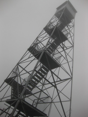
The popular summit was crowded with other groups of hikers. We were disappointed that the cab was closed, but the view from the top landing was spectacular. Ski slopes were visible, and the surrrounding Catskill Mountains decorated with the remaining orange and red leaves. The observer's cabin stands at the summit, making a nice place to enjoy your lunch.


According to "Views from on High" by John P. Freeman, the first tower on Hunter was a wooden one standing 40 feet tall. It was the first of three built in the Catskills that year. In 1917 it was replaced by a steel tower, and was relocated from it's original position to the current one in 1953. It stands at 4040 feet elevation, giving it the honor of being on the highest point of all the fire towers in New York! It was abandoned as an active fire tower in 1990 and eventually condemned for public use. In October of 2000, the tower was reopened for public use with restored steps, landings, floor, roof, paint, and windows!


To see all the pictures from Hunter Mountain, check out my Flickr page.

Cathedral Rock Fire Tower

We chose Cathedral Rock as our final Adirondack Fire Tower in the challenge. The drive took us through some peak foliage areas all the way up north to Cranberry Lake. The trail we chose, the Latham trail, starts at the Ranger School. We started off intending to take the jeep road as per the guide book but we were easily confused by all the options we had with the different roads and decided that the Latham trail seemed to be the most direct, marked traill. Besides, it is so much more fun to stroll through the woods!


On the way we passed a leaf collecting ranger student, perhaps one of the few people genuinely excited that we were near completion of the challenge. The Latham trail was very easy, well maintained with no steep areas. It brings you by a cliff overlook and up some stairs. It seems to be a popular trail and tower, there were several hikers at the summit despite the light rain.


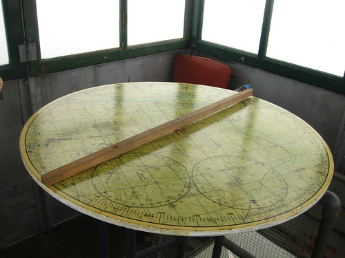
We were pleased that the tower cab was open, and even though it was a dreary day there were still a couple miles of visibility. A plaque on a large rock near the tower is dedicated to the rangers that have watched over the forest land over the years. A table map of the area is still in the tower where we tried to find Mt. Arab, one of the towers we climbed early on in the challenge, unfortunately a strange talkative intruder asked too us to many questions, creeped us out, and we left before we could find it!


Round trip distance is 2.4 miles, but I think that is using the jeep road. Elevation change is only 185 feet to the summit elevation of 1725 feet, so it is a great hike if you have little kids.

The tower once stood on Tooley Pond Mountain, and the materials were salvaged in 1971 with permission of the DEC by the students of the Ranger School. Reconstruction began in the 1980s and was completed with windows and all in 2000. I didn't notice at the time, and I can't see it in my pictures, but at one time (and maybe still) there was a rotating "stan-helio" signal at the top which reflects the sun's rays in all directions. Also known as a tin sun, it was a replica of the signal used by Verplanck Colvin to locate particular summits from a great distance.


It was a lovely hike, despite the rain and long drive.

Information on the tower and trail is from our favorite fire tower book "Views from on High" by John P. Freeman.

More pictures from the day can be seen on my Flickr page.
Saturday, September 26, 2009

Mt. Tremper via Willow Trail

After three days of partying (an out of town rehearsal dinner and wedding, and a high school reunion) I was ready for a wholesome activity. Sister and I chose Mt. Tremper because it was the closest fire tower hike left to climb, and it was a shorter hike; no need to throw my I'm-getting-too-old-to-party-like-this-body into shock. So down to the Catskills we went. We chose the Willow Trail approach because our guide book said it would save 600 feet in elevation change but only add 0.2 miles round trip. Perfect hike for my condition!


The trail begins at the dead stop end of Jessup Rd. Our guide book says its 6.4 miles round trip. We were too busy talking about my eventful week and missed the turn sign through the meadow to the trail. We came to a gorgous building with solar panels and a field of wild turkeys. The road turned around and we encountered some loggers who informed us that we did miss a turn a while back. That excursion probably added only a half mile onto our hike.


When we got back on track we climbed a little and walked along the ridge where we could hear the helpful loggers down below and a snake (not a rattlesnake) sailed over the toe of my boot. We saw Doll's Eyes in person for the first time ever! We moved forward for quite some time before getting to a junction where a sign said that there was over two miles to the summit. That, according to our calculations based on the guidebook, would mean that we had only walked about a mile from the trail head?! We took ino consideration our missed turn in Albuquerque, but it still didn't seem to check out. We hiked all the way to the summit, and towards the end of the trail we were both amazed at how it seemed like the longest 3.2 miles of our lives. I blamed it on my exhaustion and the wine from the night before.

Doll's Eyes

At the summit, much to our dissapointment, the fire tower appeared to be closed and a little unsafe to climb. Several beams were on the ground, and we speculated as to whether it was under repair and reconstruction or if the tower was going to be taken down. The pulleys and large C-clamps made us think that a restoration was in store, but the spokesperson for the family at the summit insisted it was being taken down.


No views are available from the bottom of the tower, but a large rock provided a nice sitting spot for lunch. After lunch and picture takin we continued a little down the Phoenicia trail to check out the lean-to.

Even the way down seemed equally long. I was starting to feel ashamed - we have conquored several mountains more difficult that this trail, what was my problem?! This was a fairly easy trail! We had estimated that the 6.4 mile hike would take us 3.5 hours at most, but it took us five hours including summit, picture taking, the little accidental excursion and the walk to the lean-to. How shameful! What a pleasant surprise it was when Sister found out that the Willow Trail of Mt. Tremper, according to the Catskill Center website, is actually 4.2 miles to the summit, making it about two miles longer round trip that we had thought!


An email to a Catskill Fire Tower Volunteer clarified the fire tower situation. No worries, it is under repair and it isn't going anywhere! We should have known that they wouldn't let it come down!

Wednesday, September 16, 2009

Padlock Hill Fire Tower at the New York State Fair

My husband and I made a trip to Syracuse on Labor Day Weekend. The itinerary included the New York State Fair and the Turning Stone Casino, both firsts for me! Naturally, the first thing that I noticed after walking through the gates was a structure across the grounds resembling a fire tower. My suspicions were confirmed by the fair grounds map - the DEC had an exhibit set up featuring a fire tower.


The tower was originally located on the summit Padlock Hill, near Ithica, New York. It was a 67.5 foot International Derrick tower and was constructed in 1940. According to a website created by Captain Paul T. Hartmann, the tower was first staffed in 1941 and had reported 52 fires and 705 visitors before closing in 1976. In 1977, the tower was sold in an auction to the landowner of the property it once stood on. In 1985 it was donated to the State. The tower was dismantled then reerected by Capt. Ed Pierce and the Region 7 Forrest Rangers with the help of a local steel workers union and crane owner and operator.


The sign on the fence around the tower specifically gives credit to Union Volunteers AFL-CIO, Ironworkers Local #60, Sheet Metal Workers Local #58 and Operating Engineers Local #545.

Aside from the fire tower, the DEC exhibit features a little "nature walk," camping and hiking information, and a section on insects, particularly the emerald ash borer beetle, often referred to as EAB. Native to Asia and Eastern Russia, these beetles have invaded thirteen states in the US. If you have driven through Upstate New York recently, you may have noticed the purple traps hanging from the trees. These traps are being used to locate the leading edge of infestations, as well as new populations.

The New York Invasive Species Clearing House by Cornell University maintains a website with a lot of information about EAB, from which I found more information. In their adult form feed on the edges of the leaves, and the larvae feed on the bark and inner bark of the trees. The trees are killed as the larvae destroy the phloem (inner bark), which transports nutrients made during photosynthesis. The zylem (sapwood) is also harmed by the larvae, which is tragic because this is the part of the tree that delivers water and dissolved nutrients. The tree essentially starves to death when infected by this invasive species. This is a big problem in New York because it was the ash tree that was planted to replace the native elms destroyed by the Dutch elm disease. If large numbers of mature ash trees are destroyed, the effects could be devistating, causing temperature changes, increased air pollution, not to mention the safety and economical impacts of fallen trees.

The Raptor Project was present, showing off several raptors including a bald eagle, falcons, and owls.


We passed on a four dollar Ferris Wheel ride and seeing the Worlds Smallest Woman. Shamefully, I hade a bite of my husband's fried oreo. Not what I expected - much better, actually! If you are unfamiliar, they wrap the oreo in fried dough. It tastes cakey, better than a regular oreo, but unnecessary nonetheless.


It was a fun day at the fair, and if you were wondering, I left Turning Stone with $6.75 more than what I went in with! On the way home my husband pulled over so I could take some cool pictures of the fog reflecting the orange glow of the sunset.


Tuesday, September 1, 2009

Overlook Mountain and Unexpected Mountain House Remains

On the rainy Saturday morning, Sister and I made our way down the the Catskills to climb Overlook Mountain. It was our fire tower of choice, as it was the shortest distance to cover of the three Catskill fire towers that we have yet to climb, and it was raining.

We started up the wide old carriage road, discouraged that it was not a trail under tree cover. The sky was open and raining down onto us; the rain was not heavy, but it was constant.

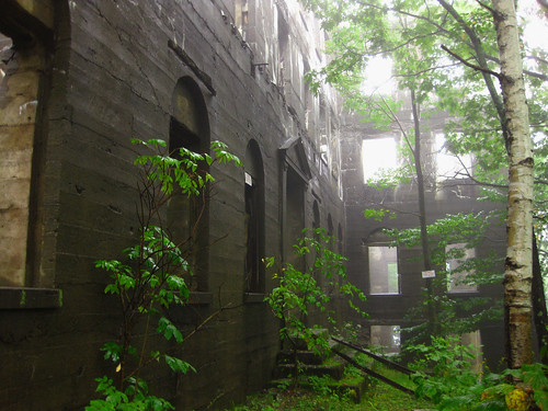
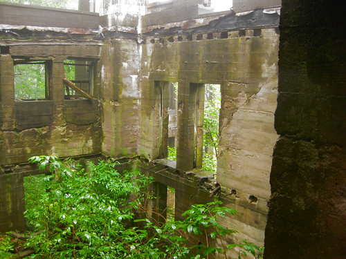
We were expecting to run into an old mountain house remains, perhaps a small foundation and a chimney. What we weren't expecting was the dilapidated monstrosity that we found. This was no observer's cabin!


According to my Views from on High book by John P. Freeman, this was a the remains of a hotel. This hotel was originally a temporary one, built by James Booth in 1833. It was given permanent status in 1871, but burned to the ground in 1874 on April Fool's Day when staff ignored a child who was trying to convince them that the smoke was darker than usual. It was rebuilt in 1878, only to burn down again in 1924. Efforts to reopen were abandoned in 1939, while in the midst of rebuilding it again.


According to the Castkill Center, the Overlook Mountain Hotel, in its prime, had the distinction of being the highest in the Catskills, at 2920 feet, and housed over 300 guests.


Rob Yasinsac provides a lot of information on the Overlook Mountain house. In his post he states that the first construction of the hotel in 1871 was done by Lewis B. Wagonen, a designer and builder from Kingston, NY. After burning down, the reconstruction of 1878 was done by the Kiersted Brothers of Saugerties. The work on the final structure was begun by Frank P. Amato. The concrete frame was quickly rebuilt, along with a chapel, underground water and ice facility, stables, and a power station, but the construction was never finished. The hotel was boarded up in 1940 and damaged by fire in 1941. A final blaze in 1961 took down much of the architecture and the roof-top tower.


The tower at the summit is restored and climbable. There are nice profile maps for the surrounding mountains along the sides of the roof of the cab, providing the climber with a guided tour of the visible area. Unfortunately, the clouds were so thick we couldn't see out the windows!


The tower is the newest of the remaining towers, built in 1927. It originally stood on Gallis Hill until it was moved to Overlook Mountain in 1950. It was eventually abandoned in 1989 and closed. Ten years later the tower was restored and opened again for climbing. In the cab a range finder and alidade are displayed.


Click here to see all my pictures on Flickr.

Sunday, June 14, 2009

Pillsbury Mt Fire Tower: Bike and Hike

My guide books warned of bad road conditions between Rt 30 and the parking lot at the trail head. When it comes off-road driving with my car, a little Corolla, I am always afraid it's going to get stuck somewhere and that I will not be able to get it out. My husband and I had a bad experience driving it to a campground down in the Catskills last summer, I was in a state of hysteria and I wasn't even the one driving!

My dentist's assistant had mentioned that she rode her bike in when climbing Pillsbury, so we decided to do it that way. We probably could have safely driven in farther than we did but I assured Sister that biking in would be a lot less worse than being stuck in the car with hysterical me.


WOW. For the 3+ miles from where I parked to the trail head we had to alternate walking with biking, and we encountered a lot of unfriendly sand. There were parts where I said "I could have totally gotten my car in here" followed by.... "I am SO GLAD I didn't take my car in here." However, there were a few little sedans in parking lot that apparently made it in without harm. Nonetheless, it certainly added to the adventure. We would not have gotten to see the snake if we drove in. And we wouldn't have been able to say we did it!


For an easy 1.6 mile walk to the summit, the trail seemed to last forever! It probably had something to do with the 3 mile bike ride in, but after a while we began to have tower mirages, which is a phrase we made up for when you are so ready to see the tower that you actually start to think that trees and branches are the tower up ahead.

On the way up we saw toads, wild flowers which Sister can name, and a dead moth with a pattern on its underside that resembled two eyes staring up at us.


The tower is climbable but the cab is not accessible. The fierce wind forced us to hurry back down to the ground not giving us time to look for other mountains such as Snowy and Wakely which also have fire towers.


There is a nice little bench and a wooden ergonomically designed makeshift chair surrounding a fire pit where we enjoyed our lunch.


Round trip from the time we left the car on our bikes to the return to the car was about 4 hours. This included a total of 6 miles biking and 3.2 miles hiking. Not too bad.


Elevation change: 1337
Total Elevation: 3597
Round trip from trail head: 3.2 miles

Click here to see all the pictures.

Tuesday, June 2, 2009

Memorial Day Hike: Wakely Mountain Fire Tower

We began our Memorial Day at 7am leaving home and driving all the way up to Wakely Mountain through the towns of Warrensburg, Wevertown, and Indian Lake. A little more than 11 miles outside of the town of Indian Lake, down Cedar River Road, the trail head of Wakely Mountain sits. The road off of Rt 28 is a little scary, but fortunately does not require four wheel drive. In the winter it is only partially plowed, up to 4.6 miles before the trail head, requiring snowshoes or a snowmobile to get through the remainder of the road.

The trail begins on what appears to be a snowmobile road, where the Warning sign is posted regarding the washed out road. Don't fear - it is easily accessed on foot! The elevation change for the first mile of the trail is barely noticeable. A sturdy footbridge helps you across a brook along the way. We encountered a toad and some wildflowers along the way, including a painted trillium, violets, and some hobblebush.


It's not the best marked trail, but it is pretty obvious where you need to go. At one point you will come across a clearing straight ahead, as the trail veers off to the right. The clearing is the site of an old beaver pond. As you continue along the trail, you will see a side path off to the right which would lead you to a helipad site, visible from the tower.

We were expecting much worse for the final stretch which is an approximate 1100 foot elevation change over about a mile. However, the tower actually snuck up on us sooner than expected. Not too difficult for a three mile distance up a mountain that is only 256 ft short of being a high peak! The mosquitoes were more numerous than the black flies, and laughed at the bug spray despite our multiple applications. They weren't biting as much as they were just annoying, reminding me how I need to learn how to breathe with my mouth closed!


At 70 feet tall, this is the second highest standing tower in the Adirondacks - it is the tallest one that is currently climbable! I believe that most of the towers we have climbed had a chicken wire-like netting around each platform, but this does not, so watch your step because it's a long ways down. One platform on the top half of the tower has a loose board, so beware! I had to sit down on the topmost platform; between the wind, the insecurity of no protective chicken wire , and the massive height of the tower, I had my first experience of fire tower vertigo.


Not only did it lack chicken wire protection, but there was a ladder into the cab of the tower as opposed to stairs, and of course the ladder doesn't have anything for protection on the sides either! Before the stairs and landings were built, the ladder used to be the only access to the cab - can you imagine?! While it was bad timing for me to get vertigo 70 feet above the ground, for some reason I was more worried about dropping my camera than anything. Brave sister went up the ladder first, I followed after regaining my balance and breath. There are some amazing views from that high up! We could pick out Snowy Mt, which we had climbed earlier this month. I found the three high peaks that I get confused and can never tell which of the three is Mt. Marcy. The observer's cabin looked like a little Monopoly piece and we could see the helipad through the trees. A graffiti-tainted poster of Smokey the Bear is peeling off the wall of the cab and unfortunately there is some other graffiti inside the cab, but not as bad as other towers that we've been in. One lonely glass window remains, I assume the rest have all been broken.


On land we tried the door to the cabin, which was unlocked. The interior was surprisingly pristine, unusual for an unlocked and unsupervised cabin. With the aid from the flash of our cameras we could see two cots and a night stand in the bedroom. The kitchen table displayed some antique pickle and flour jars.


The hike took four hours including tower, cabin, and sunbathing time, shorter than what we had expected. It was a comfortable temperature and a beautiful day! Check out all the pictures from the hike on my Flickr.

Below is a video that I attempted to make artistically with most of the pictures that I took and a few from Sister's collection. It was inspired by the beautiful views from the tower and brief vertigo spins attributed to my newly found mild fear of heights. The song used is "Sober" by P!nk.


Friday, May 15, 2009

Snowy Mountain Fire Tower

After a failed attempt at the climbing the closed Schaefer trail at Gore Mountain, Sister and I found ourselves at the trail head of Snowy Mountain facing a 6.8-7.8 mile hike (depending on the source of information) at 1pm for a shot at redemption.

The first part of the hike in was really easy, and the entire trail is well marked and well maintained. There seems like hardly any elevation for maybe the first mile or two, with a couple of minor obstacles. The first challenge was getting our short legs from one stepping stone to the next when crossing the brook which was generously fed by the Spring's snow melt. The trail actually leads you across the brook several times, bouncing from one stone to the next, and at times leaving you wondering why you need to cross here if you will have to cross back over again in a few minutes.


At one point we were led to still body of water with a foot bridge across the length. Unfortunately, a good portion of the bridge is under the murky water- several inches deep. Going around to the left there was a dam of sticks and downed trees. It got a little tricky between the slippery wet wood, rolling logs, with not much but a trekking pole to hold onto for balance. It was better than wading across though!


The last mile or so is where the trail turns into an intense incline, we only had to stop and sit once. The last portion of the trail is relentlessly steep, punishing you for the first mile of cake walk. We did, in fact, encounter snow toward the summit of Snowy Mountain, as well as mudslides, and nearly completely vertical slopes up the stream.

We were rewarded with a spectacular view at an overlook facing Indian Lake, and the tower was not much farther from the overlook.

The summit is almost completely enclosed, but climbing the tower will provide you with a 360 degree view.


On the way down we encountered a few shy newts, and a gorgeous full rainbow. We completed the trip in 6 hours including our snack on the summit and picture taking.


Check out all the pictures from this hike.