Lucky Number Seven
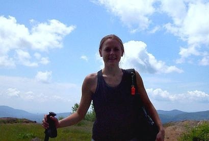
Our hike up Blue Mountain, the seventh fire tower mountain we've conquered in the Fire Tower Challenge, tied together a few rarities for us on our Sister Hikes:
- A climbable tower including access to the cab
- An amazing 360o view
- Blue skies - no rain or over-cast to obstruct the view available
At the trail head, hikers are provided with a self-guided tour guide, much like the one on
Mt. Goodnow. The first station explains that Blue Mountain is located in The Adirondack Park, which was created in 1892 and is the largest park in the 48 continental states. Forty-five percent of the park owned by the public, but the trail head and parking lot of Blue Mountain is owned by Finch, Pruyn, & Company. The summit is NY State land.
Here is a picture of a balsam fir growing on a rock as a response due to competition for space in the crowded forest. Balsam firs have many uses such as oil of fir, manufacturing of perfumes and incense, balsam pillows, paper from the wood, and the sticky resin is an ingredient is Save the Baby, a repellent for black flies.

This is a mushroom I came across, I'm not sure what its called, but the underside was was more interesting that its top.

The pamphlet explains that this little stream here is on one of the five major Adirondack watersheds. It will make its way to the St. Lawrence River, and eventually to the ocean. Hikers are warned not to drink water from streams, as they can harbor
Giardia, a parasitic microorganism that will no doubt ruin your vacation and make you wish you weren't in the woods. It is noted that crossing this stream marks the end of the first 1/3 of the trail, but there was no warning that the trail had been deceivingly easy up to this point, and the final 2/3 would be much more difficult.

Here is a yellow birch tree, much different looking than the white birch. This type of birch tree commonly germinates on rocks and decaying logs. Branches of young yellow birches smell of wintergreen and pioneers would boil the branches and leaves to make tea and birch beer.

During the last ice age, the area was covered by glaciers which acted like sandpaper, carving and polishing the land scape. The crack is probably from an earthquake and is over 1.15 billion years old. The mountain, however, was formed with the rest of the Adirondacks only about 5 million years ago, and still rising about 1mm per year. You will have to take my word that the stretch of smooth, bare rock was the hardest part of the hike. My pictures never do the steepness of the slope justice.

At last, the tower! Sister took a picture of me up inside the cab, click on the picture for a close up shot. Regrettably, the rumored college intern interpreter at the top was once again no where to be found. With map and compass in hand, I acted as interpreter, trying to decipher the surrounding landscape and bodies of water.

The large lake is Blue Mountain Lake. To its left is Eagle Lake. You can barely make out what I think is Raquette Lake way in the back.

Minnow Pond, Mud Pond, and South Pond are in this direction, but don't ask me which is which.

Tirrell Pond, Tirrell Mountain behind it. Just to the left I think is Tongue Mountain (not to be confused with the Tongue Mountain Range) - Algonquin Mountain in line with Tongue Mountain. Just to the right of the gap by Algonquin should be Avalanche Pass and then Mount Colden )I think) is the second highest behind Tirrell Mountain, but I could be wrong. Keep in mind, just finding a trailhead is a challenge for me!

This is the observer's cabin- barred, boarded, locked, and covered in graffiti.

For all the pictures, and some further detail, see my
Flickr set.The Adirondack Mountain Club selected the fire tower on blue Mountain in 1993 to draw attention to fire towers' restoration potential throughout the Forest Preserve. With over 15,000 visitors a year, it is very popular. The restoration later was assumed by the Cornell Cooperative Extension agen for Hamilton County, and the DEC forest ranger and Indian Lake's town Supervisor.
In 1994, the tower was revitalized and an intern was hired to provide interpretation to greet the public at the summit.
Originally, the Iroquois named the mountain To-war-loon-da, which means the Hill of Storms. It was later renamed Mount Clinch, after a state assemblyman who was in support of the Eckford survey of 1811. At that time, Blue Mountain Lake was called Lake Janet, after Ecfkord's daughter.
Verplanck Colvin's Adirondack Survey crews had set off their bright explosions each night, allowing them to synchronize their chronometers, improving the accuracy of their latitude and longitude determinations.
Verplanck Colvin was a lawyer and topographical engineer obsessed with finding the altitudes of the highest peaks in the Adirondacks. His actions lead to the Forest Preserve and creation of the Adirondack Park.
Round Trip Distance: 4.0 mi
Elevation change: 1550 ft
Summit Elevation: 3759 ft
Difficulty: Starts out really easy, look out in the middle. The steep part seems to go on forever. Overall difficulty is moderate.
Information from:
Views from on High: Fire Tower Trails in the Adirondacks and Catskills, by John P. Freeman
Blue Mountain Trail Guide: Rocks Ice, Trees, Steel and History prepared by students at the State University of New York College of Environmental Science and Forestry.
http://en.wikipedia.org/wiki/Verplanck_Colvin


